 Add Row
  Add
Add 


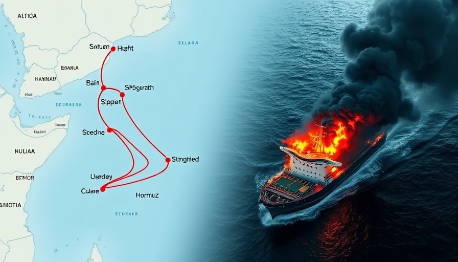
Understanding the GPS Interference in the Strait of Hormuz
The Strait of Hormuz, a critical maritime chokepoint, separates Iran from the Arabian Peninsula and serves as a route for a significant portion of the world’s oil supply. In recent years, there has been an alarming rise in incidents of GPS interference in this vital waterway. This interference threatens navigation safety, potentially leading to maritime accidents that could have dire consequences, both economically and environmentally.
The Consequences of GPS Disruptions
GPS disruptions can have far-reaching implications. Vessels rely heavily on GPS for navigation, especially in congested areas like the Strait of Hormuz, where visibility can be limited due to weather conditions or heavy traffic. According to maritime experts, the growing incidents of signal jamming or spoofing can lead to collisions, stranding, or even oil spills, reinforcing the necessity of reliable navigation systems.
Historical Context of GPS Interference
GPS interference isn't a new phenomenon, but it has intensified in recent years as geopolitical tensions have escalated. Historically, various states have employed jamming techniques as a means of control or deterrence, particularly in conflict zones. Iran, for instance, has been implicated in numerous incidents, often as part of a broader strategy to assert territorial claims and deter navigation by foreign military vessels.
Implications for Global Trade
The increased risk of accidents due to GPS troubles poses a serious threat to global trade. The Strait of Hormuz is a pivotal passage for tanker traffic transporting oil from the Gulf states to markets worldwide. Disruptions to this pivotal trade route can cause price spikes in oil and other commodities, lead to supply chain disruptions, and negatively impact economic forecasts, highlighting the urgent need for diplomatic solutions to ensure safe navigation.
Possible Solutions to Mitigate Risks
Addressing the issue of GPS interference requires coordinated efforts from international maritime organizations, governments, and the technology sector. Possible strategies may include investing in alternative navigation systems, improved signal verification technology, and diplomatic engagement to reduce the likelihood of state-sponsored interference. Enhancements in the resilience of maritime infrastructure could also play a part in safeguarding navigation for both commercial and military vessels.
Future Predictions and Trends
As technology evolves, the potential for further advancements in navigation safety is promising. Innovations in satellite technology, integrated navigation systems that combine multiple forms of data, and increasing collaboration across nations can help mitigate the risks posed by GPS interference. The future of maritime safety in the Strait of Hormuz hinges on our ability to adapt to these emerging technologies and collaborate globally.
Conclusion
The risk associated with GPS interference in the Strait of Hormuz is a complex issue at the intersection of technology, geopolitics, and maritime safety. As this situation evolves, staying informed about developments in navigation technology and international partnerships will be essential for anyone concerned with maritime safety and global trade. The world must advocate for a reliable navigation system and navigate these geopolitical waters with caution.


Write A Comment