 Add Row
  Add
Add 


The Dawn of Real-Time Wildfire Detection
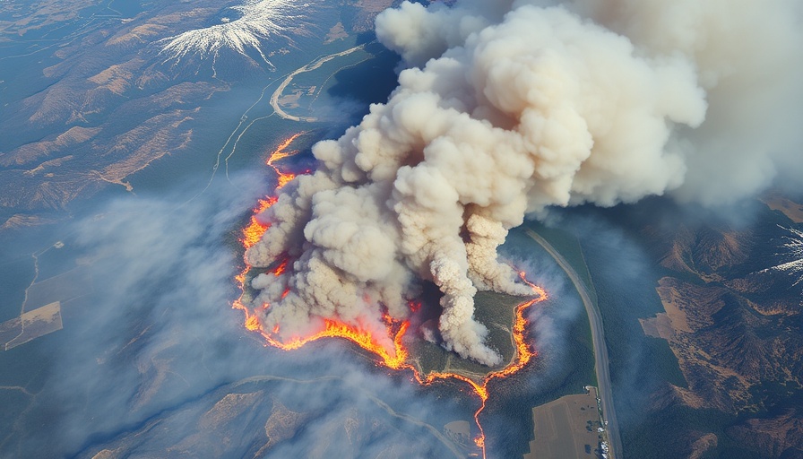
In a groundbreaking step towards more efficient wildfire management, the first satellite of the FireSat constellation has successfully entered orbit. Launched on March 14, 2025, by Muon Space aboard a SpaceX mission, this satellite heralds a revolution in wildfire detection, equipped to deliver more accurate and frequent imaging than ever before. With the capacity to cover nearly the entire surface of the Earth every 20 minutes, operational capabilities are set to expand significantly by 2026, marking a leap forward in environmental monitoring technology.
Transforming Wildfire Tracking with Technology
Traditional methods of tracking wildfires often rely on expensive aerial photography or low-resolution satellite imagery that can take hours to update. Aerial surveillance offers limited coverage, while existing satellite imagery lacks the specificity to detect smaller wildfires before they escalate. The FireSat constellation is tailored to address these shortcomings, providing five-meter resolution imagery and speedier updates on fire activity. This development is crucial as it can offer emergency responders timely data, potentially saving thousands of acres and lives.
The Backbone of FireSat: Collaboration and Funding
The project stands as a collaborative effort among multiple stakeholders, including Google, Muon Space, and the Earth Fire Alliance, which brings together nonprofits and academic institutions dedicated to wildfire mitigation. The initiatives also receive financial backing from prestigious organizations such as the Gordon and Betty Moore Foundation and the Minderoo Foundation, emphasizing the collective responsibility in tackling the growing threat of wildfires globally, fueled largely by climate change.
Historical Context: The Increasing Threat of Wildfires
Record-breaking wildfires have increasingly become a global threat over the past few decades, exacerbated by climate change. Previously, emergency responders often lacked the precise data necessary for effective fire management. This gap in information has led to catastrophic outcomes for communities, as illustrated by personal stories like that of Juliet Rothenberg. She faced a terrifying evacuation during a California wildfire without timely updates regarding the threat to her neighborhood. Innovations like FireSat not only promise more reliable data but also aim to prevent such dilemmas for others in the future.
Future Predictions: The Impact of FireSat on Climate and Community
Once fully operational, FireSat's transformative capabilities are expected to fundamentally alter wildfire management. Many predict that its advanced detection technology will herald a new era for climate science as well. By actively monitoring wildfires and capturing data on their movements, FireSat will contribute to a clearer understanding of fire behavior, trends over time, and even help in modeling CO2 emissions associated with wildfires.
The Importance of Timely Data: Life-Saving Insights
Timely information is critical in wildfire situations; when responders are equipped with accurate and rapid data about active fires, they can deploy resources more effectively. The intricate sensor suite of the FireSat satellites actively monitors small fires just starting, providing crucial insights that can help prevent larger disasters from unfolding. Emergency services can respond faster, preventing loss of life and community damage while also providing better preparedness for their inhabitants.
Common Misconceptions: Understanding Satellite Technology
A common misconception surrounding satellite technology is that it only provides overview imagery of massive areas. FireSat directly tackles this myth by demonstrating its ability to distinguish small fires the size of a classroom within short timeframes. Its innovative design and use of AI help differentiate between real fire incidents and environmental noise, reflecting the significant advancements in satellite technology.
Take Action: How FireSat Can Influence Your Community
The launch of FireSat marks not only a technological leap but also a vital tool for community safety. As active participants in our communities, citizens can advocate for support and funding for high-tech surveillance solutions like FireSat in local government discussions related to disaster preparedness and climate action. Your voice is essential in driving technological innovations that can save lives and protect our natural resources.


Write A Comment